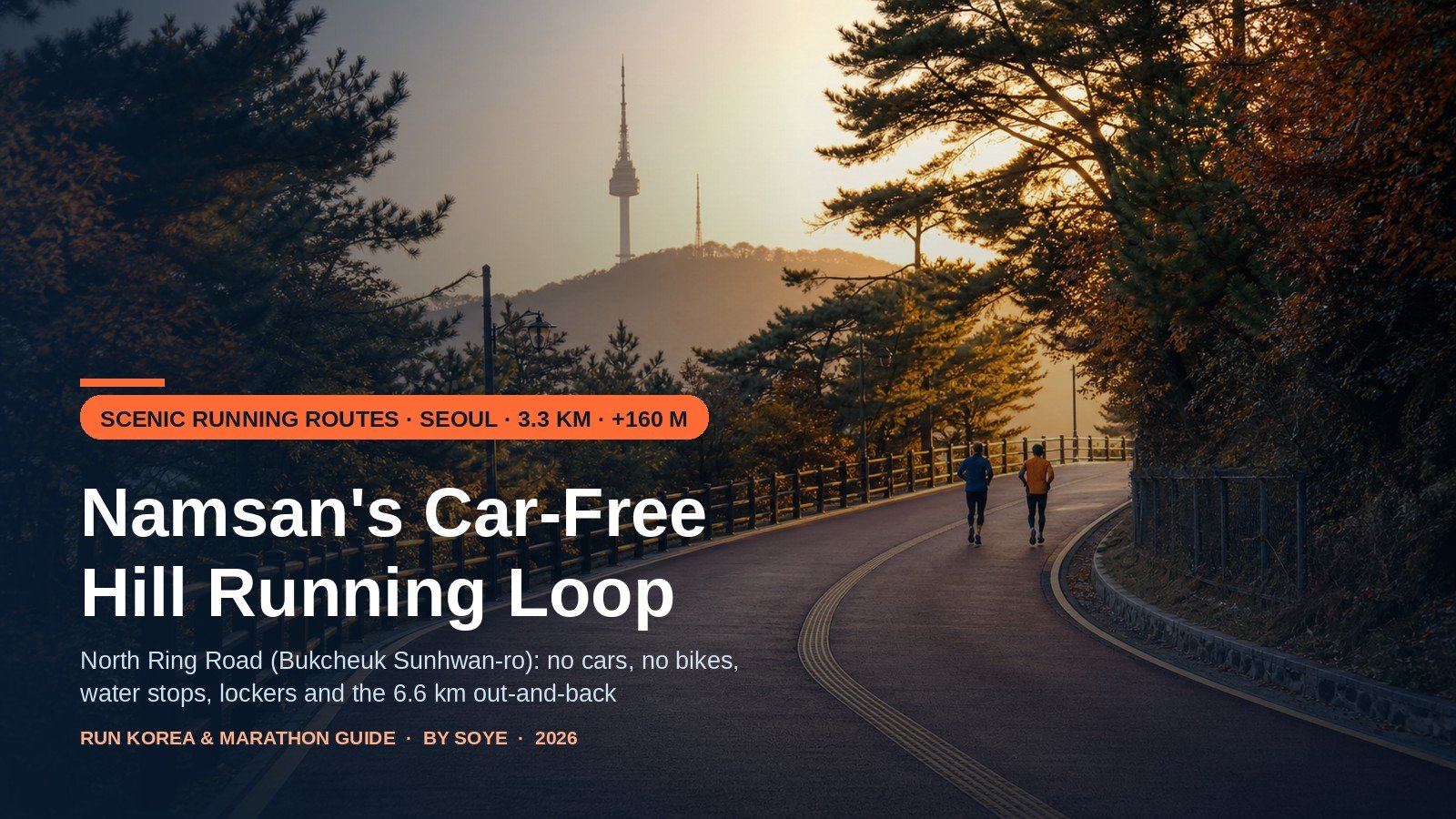
There is one road in central Seoul where a marathon club can run hill repeats at 7 a.m. with no car, scooter or bicycle passing them — and where a blind runner can walk the same stretch alone with a cane. It is 3.3 km long, wraps the north flank of Namsan from the National Theater to the cable car, and gains about 160 m over the out-and-back. Locals call it 북측순환로 — the North Ring Road.
It is also the most mis-described running route in the city: still billed as a rubberised urethane track (it was, until 2018), still listing fountains that are off from mid-November, and silent on bags — because there are no lockers on the loop at all.
Quick Verdict
Seoul’s best car-free hill loop: 3.3 km one way, 6.6 km out-and-back, about +160 m, closed to cars and bikes since 1991. Start at the National Theater, carry water from 15 November to 15 March, and park your bag in a subway locker or the free trailhead shower room.
What this loop actually is (and the surface correction)
Namsan’s ring road splits in two. The north ring runs from the National Theater (국립극장) past the Silla and Banyan Tree hotels, through pine forest and the Waryongmyo shrine, to the cable car at the western end. The south ring closes the circle on the city side, from Namsan Library past Baekbeom Square up to the tower.
The north half has been pedestrian-only since 1991, when the city’s Namsan restoration closed it to traffic. Cars, taxis, motorcycles and bicycles are banned; the only vehicles you see are a maintenance truck or an ambulance. At 6–8 m wide, with a yellow tactile strip down the centre — the city calls it the “path of consideration” (배려의 길) — it is why you pass blind runners and cane users on a mountain road, as nowhere else in Seoul.
Now the correction. In 2007 Seoul replaced half the asphalt with a springy rubber-urethane lane, which is why older articles — including some city pages still online — call this a urethane track. In 2018 the whole 3.3 km was resurfaced in coloured asphalt, with a 750 m barefoot clay strip (황톳길) added beside Seokhojeong. Today it is firm, faintly reddish asphalt: fast, grippy when dry, honest underfoot. Not a stadium track — you will feel the descents in your quads. A daily trainer is right; trail shoes are unnecessary.
North ring vs south ring vs a flat Han River loop
The comparison that decides most runners’ week: hills with no traffic, or miles with no thinking?
| North Ring (북측순환로) | South Ring (남측순환로) | Yeouido Han River | |
|---|---|---|---|
| Distance | 3.3 km one way (signage 3.4 km) · 6.6 km out-and-back | 4.1 km one way · joins the north ring into a 7.5 km circle | 8.4 km flat loop |
| Climbing | ~+160 m out-and-back; a hill every 400–600 m | The bigger climb, with long sustained grades to the tower | Flat, a few bridge ramps |
| Surface | Coloured asphalt since 2018; 750 m clay strip | Asphalt road plus a narrow rubberised foot lane | Asphalt riverside path |
| Cars | None since 1991 (maintenance, emergency only) | Yes — 01A/01B shuttles, taxis, cars; 20 km/h, one-way | None |
| Bikes | Banned | Allowed downhill only; a known collision risk | Separate lane alongside |
| Bags | No lockers on the loop; stations 5–15 min away; free shower at the west end | Same; library end is closest to lockers | Convenience stores, no lockers on the path |
| Best for | Hill repeats, terrain tempo, marathon strength | Long climbs, scenery, the full circle | Easy long runs, pace work, beginners |
Use the north ring when you want work: the only place in central Seoul to run hard without a traffic light or a delivery scooter. Use the south ring to add distance and climb, sharing the road with buses. Use the Han River when the plan says easy — see the Yeouido 8.4 km loop guide.
Three trailheads, three different runs
Where you start changes the run: the approaches are steep and the first kilometre sets your rhythm.
| Start | Walk to trailhead | Approach gradient | Lockers / toilets | Trade-off |
|---|---|---|---|---|
| Myeongdong Stn. Exit 3 (Line 4) | ~10 min uphill to the cable car | Steepest — roughly 70 m of climb in 1 km on city streets | T-Locker, 77 compartments; cable-car toilets | Best from a Myeongdong hotel; you finish downhill into dinner, with warm legs whether you wanted them or not. |
| Dongguk Univ. Stn. Exit 6 (Line 3) → National Theater | 10–15 min through Jangchungdan Park | Gentlest — a short ramp onto the ring road | Only 13 compartments at the station; park and theater toilets | The local default: the climb builds gradually, and the park is a warm-up spot. |
| Namsan Library / Hoehyeon Stn. (Line 4) | Bus 402 or the 01A/01B shuttle to the library | Rolling from the start, long climb ahead | Library-gate toilets; T-Locker at Hoehyeon and Chungmuro | For the full 7.5 km circle. More climb, more scenery, buses for company. |
From Dongguk University, Exit 6 puts you on the right side for the theater, and the 01B shuttle behind the exit stops at “남산북측순환로입구” (North Ring entrance). From Myeongdong, Exit 1 — not Exit 3 — is the one for the free shower room, nine minutes on foot.
Bags, lockers and the free shower nobody mentions
There is no locker on the loop and no café or convenience store either — the most common surprise for visitors. Two solutions:
1. Subway lockers (또타라커 / T-Locker). Seoul Metro’s network opens 05:00–24:00 and charges by four-hour block: small (50×30×60 cm) ₩2,200 weekdays and ₩3,100 at weekends, medium ₩3,300/₩4,600, large (50×90×60 cm, cabin-bag size) ₩4,400/₩6,100, then ₩500–1,000 per extra hour. Around Namsan: Myeongdong has 77 compartments at four points — one bank by Exit 1, three inside the Exit 4 gates, which sit in the paid area and need a ticket; Chungmuro has 49; Dongguk University has just 13. No app required: scan the QR, pick a compartment, and choose “International” at payment for a foreign Visa, Mastercard, AMEX, JCB, UnionPay or PayPal. You get a six-digit one-time PIN, reissued on the same screen when you return. Hotline 1877-1265.
2. The Namsan runner shower room (남산 러너샤워장). The local secret, and free. On the ground floor of the Jungbu Park & Leisure Center, 231 Samil-daero (예장동, nine minutes from Myeongdong Exit 1), the city runs a shower facility for runners and cyclists every day 06:30–22:00. Individual booths, changing area, hairdryers, and free lockers usable separately from the shower (same hours, same-day pickup). Sign the paper log, check in by QR, bring a towel. For a pre-flight run or a 9 a.m. meeting, it is the difference between a good morning and a grim one.
Water and toilets: the 15 November switch-off
Namsan has 16 fountains and 12 toilets across its 2.9 million m². On the north ring you pass three — at Seokhojeong (the archery range), at the No. 1 tunnel, and at 목멱산방 by the cable car — plus Jangchungdan Park at the trailhead and the gate block at Namsan Library.
Water is the seasonal variable. On 11 November 2026 the city announced that all 1,880 outdoor Arisu fountains in Seoul would shut off from 15 November until 15 March 2027 — every fountain on Namsan included. Indoor fountains stay on, so the library and park visitor centre are your refill points, not the roadside taps. From mid-November to mid-March, treat it as self-supported: 500–750 ml for one out-and-back, and skip the old 약수터 spring on the south side, which is marked non-potable.
The 3.3 km, segment by segment
East to west, National Theater to cable car; distances approximate, from landmark order along the road.
- 0.0–0.7 km · Theater forecourt to the pine healing forest. The ramp off the theater plaza is the steepest thing you meet for three kilometres. Let the first 300 m feel too slow, and use the softwood forest entrance (남산소나무힐링숲) as your checkpoint. Conversational — if you are breathing hard here, you started too fast.
- 0.7–1.4 km · Healing forest to the Pildong lookout. Gentle rolling, mostly shaded, with the first gap in the trees over Dongguk University. Lock your cadence here: count 30 seconds of steps and hold it. Steady, one gear up.
- 1.4–2.1 km · Pildong lookout through Seokhojeong and the clay strip. The first real climb, past the archery range and the 750 m barefoot clay path. Stay on the asphalt and shorten your stride rather than pushing. Comfortably hard; where hill repeats usually turn.
- 2.1–2.7 km · Seokhojeong to Waryongmyo. Crest, recover, quick descent to the blue gate of Waryongmyo, the shrine to Zhuge Liang and Dangun that has stood here since the 1930s (open roughly 08:00–16:00, no photos inside). One short kicker after the gate. Back to steady.
- 2.7–3.3 km · Waryongmyo to the cable car and 목멱산방. Forest, a fast runnable descent, then 400 m flattening to the cable-car plaza. Turn here for 6.6 km, or climb the stairs to the tower for 2 km of much steeper work. Free speed on the descent — the quads pay for the earlier climbing.
Two adjustments make it a session, not a sightsee. Run it the other way on your second visit: the profile inverts and the long descent becomes a kinder uphill. For hill repeats, use the Pildong-to-Seokhojeong rise (segment 3) — 700 m up, 400 m jog down, no road to cross.
How Seoul’s runners actually use it
This is the hill where the city’s clubs do their strength work. On weekend mornings the theater forecourt and the cable-car plaza fill with club runs — packs of ten or twenty in both directions, faster groups on two or three laps. The unit of currency here is “one lap”, which locals mean as the 6.6 km out-and-back, never the 3.3 km one-way.
The standard session is two laps (13.2 km) easy, or one lap plus the tower climb for 8.5 km with the hardest 2 km last. Autumn marathon blocks bring three-lap mornings — 19.8 km with 480 m of climbing, a better hilly-race simulation than flat. After dark the road stays busy until about 21:00 and the park lamps (1,046 across Namsan) light the main line, but the forest-to-Waryongmyo stretch goes properly dark. Traffic risk is nil; footing and visibility are the real hazards.
Winter: ice, snow clearing and the shuttle detour
December to February turns this into a different run. Snow is cleared quickly — the road is runnable within a day of a fall — but the shaded bends between the pine forest and Waryongmyo hold ice for days after a melt-and-refreeze. On those mornings, run the sunlit western half and skip the shaded middle, or take the south ring’s rubber lane.
The 01A/01B shuttles detour on snow and ice days, skipping both the North Ring entrance and the tower stop — your easy way up or down can quietly disappear, so keep a walking route in reserve. And the fountains are dry until 15 March. Layer for a 3–5°C gap between the sunny theater side and the shaded north face; the Seoul winter gear guide covers each band.
The recovery route: jokbal, sundae-guk and a stretch
The best reason to finish at the theater end is what is twelve minutes downhill. Jangchung-dong’s jokbal alley (장충동 족발골목, Jangchungdan-ro 175), 150 m from Dongguk University Exit 3, has fed athletes since the Jangchung Gymnasium days: braised pig’s trotters sliced cold with salted shrimp, lettuce and iced dongchimi broth. The original is Pyongando Jokbal (평안도족발집, closed Mondays), where a small order is ₩30,000 and feeds two hungry runners, with makguksu and bindae-tteok at ₩8,000 each. For soup, Jangchung Bonga Sundae-guk and Mubongri Sundae-guk (09:00–22:00) serve blood-sausage and pork soup for around ₩10,000.
Stretch first: Jangchungdan Park has flat ground, benches and shade, and it is where the clubs cool down. For the deeper recovery menu — what to eat in the hour after a long run — see post-long-run nutrition in Seoul, and for the wider shortlist, the five most scenic routes in Seoul.
Before you run it: six checks
- Grip, not cushion. A fast descent means tread beats foam; worn flats slide on the clay dust near Seokhojeong.
- A removable middle layer. The north face runs 3–5°C colder; a shell round your waist beats a jacket you carry.
- Your own water, November to March. Every outdoor fountain is off; 500 ml covers one lap.
- A plan for your bag. No lockers on the loop — Myeongdong (77), Chungmuro (49), or the free shower-room lockers at 231 Samil-daero.
- Sunset time and a light. The lit line ends where the canopy starts; chest light or reflective band, November to February.
- Left-hand rule, quiet voice. A blind-runner route with tactile paving down the middle: pass on the right, and never stop dead on the centre strip.
Frequently asked questions
Can I ride a bicycle on the North Ring Road?
No. Bicycles and motorcycles have been banned since the road went pedestrian-only in 1991, alongside cars. The south ring allows bicycles downhill only, mixed with buses and cars at a 20 km/h limit — no relaxing alternative.
Is it safe to run here at night?
Yes, with a light. No traffic, so the risks are footing and visibility. The main line is lit and busy until about 21:00, but the stretch between the pine forest and Waryongmyo goes properly dark, and a small chest light is the local standard from November to February. The park is open around the clock.
What about ice in winter?
Snow is cleared fast, but shaded bends hold ice after a melt-and-refreeze. Then run the sunlit western half, or switch to the south ring’s rubber lane. The 01A/01B shuttles also detour on ice days, skipping the North Ring entrance and tower stops, so keep a walking route down.
Are dogs allowed?
Yes, on a leash — the city’s Namsan trail guide lists the 7.4 km loop as open to leashed dogs. You will see a handful, mostly on the theater side. Bring bags and keep the leash short around blind runners and the archery range.
Where are the toilets, and is there water on the route?
Three on or beside the north ring — Seokhojeong, the No. 1 tunnel end and 목멱산방 — plus Jangchungdan Park and Namsan Library. Water is the catch: all outdoor fountains in Seoul, Namsan’s 16 included, are off 15 November to 15 March. Carry a flask and refill indoors.
Where do I leave my bag?
No lockers on the loop. T-Locker at Myeongdong (77), Chungmuro (49) or Dongguk University (13, one large); or the free lockers in the Namsan runner shower room at 231 Samil-daero, 06:30–22:00, same-day pickup.
Is the loop 3.3 km or 3.4 km?
Both, depending on who measured. City signage says 3.4 km; most watches say 3.3 km for the theater-to-cable-car stretch. Plan on 6.6 km out-and-back and treat 6.3–6.6 as normal GPS drift under the trees.
Final Summary
- The route: North Ring Road (북측순환로), National Theater to the cable car — 3.3 km one way, 6.6 km out-and-back, about +160 m, cars and bikes banned since 1991. One lap means the out-and-back.
- The surface: coloured asphalt since the 2018 repaving, not the old urethane lane. Normal road trainers; the only steep bit is the approach ramp from the theater.
- Start here: Dongguk University Exit 6 for the gentlest approach, Myeongdong Exit 3 for the steepest and the best finish, Myeongdong Exit 1 for the free shower room.
- Water and bags: outdoor fountains are off 15 Nov – 15 Mar; no lockers on the loop — Myeongdong (77), Chungmuro (49), or the free shower-room lockers at 231 Samil-daero.
- After: Jangchung-dong jokbal alley, 150 m from Dongguk University Exit 3 — Pyongando Jokbal for the original, sundae-guk for soup.
Last checked: 17 November 2026. Sources: Namsan Park facilities, toilets, fountains and the runner shower room from Seoul’s parks service (parks.seoul.go.kr); the pedestrian-only status and 2018 coloured-asphalt resurfacing from Seoul Metropolitan Government announcements; the winter shutdown of 1,880 outdoor Arisu fountains from the Seoul Arisu notice of 11 November 2026; T-Locker tariffs and hours from Seoul Metro; 01A/01B route, fare and winter detours from the N Seoul Tower guide and Seoul bus data; Waryongmyo from the Encyclopedia of Korean Culture. Surfaces and hours change; check the trailhead board.